Aloha. I'm back on the Kilo Moana for another mission. This is a short HOTS (that stands for Hawaii Ocean Time Series) cruise. We left port near Sand Island this morning (July 2) at about 9am, stopped just west of 'O'ahu for one station of data sampling, and now we're headed north towards the station where the bulk of the science will take place.
I have a bit of a computer situation, and to make a long story short, I'll be blogging short messages without (for the time being) pictures. I'll see if this can be remedied any time soon.
The point of the cruise is to see what's changing in the ocean over time. Dissolved carbon dioxide (and the acidity associated with it) seems to be rising just as atmospheric carbon dioxide is rising, and this project is largely motivated by studying the details of that. But as long as we're headed out (and HOTS cruises go out about monthly), there's plenty more science to be done, and plenty more scientists jumping at the chance to join and study their particular interests. On this cruise, we seem to have several biological types, one group interested in the chlorophyll in the water (which means the photosynthsizers in the water), and another interested in the DNA in the water (which means all the life in the water, I guess.)
There's also a group from UW studying CFC's (remember those from the ozone-days?) as a tracer. Because CFC's entered the water at the surface all over the world (back when we didn't know better), the water that was then at the surface is now marked with a CFC signature - a signature which isn't likely to be erased because CFC's are so unreactive. (They're also harmless to marine life, as far as we know.) So measuring CFC's in water can help researchers learn something about circulation and mixing.
We're an interesting mix - from the ship's employees, to scientists, to us lowly volunteers. We have a 13-year-old intern joining us, as well as an interesting volunteer whom I'll call Steve. Steve is "like me" - he has a family and a career, and he's out here to do something different and learn something. But in real life he's an entrepreneur, and among other things, he has a website that apparently everybody checks and gets a bazillion hits - it's called engrish.com and you should check it out.
If you want to know more details about the ship (like where we are in real time), you can check the ship's website http://iminia.soest.hawaii.edu/UMC/amarcen.htm Let me know if that doesn't work.
I'll do my best to keep up with this as often as I can - hopefully with frequent but short updates.
Patricia
Thursday, July 2, 2009
Tuesday, June 10, 2008
Our last day at sea
NOAA Teacher at Sea: Patricia Kassis
Aboard the R/V KILO MOANA
Date: 10 June 2008
Geographical Area: Central Pacific, North of O’ahu
Science Log
We have remained at the buoy site today. We continue to do the meteorological measurements from the bow (sea surface temperature and humidity), we did a single CTD cast just to test that the instruments were working right for the next cruise, and we've been monitoring the data from the new buoy and comparing them to data the ship is collecting.
The mooring data we've been watching especially closely is the wind direction, which was off before we replaced the anemometer yesterday. And it turns out... the wind direction is still off. The two anemometers still record a difference of about 30 degrees. Although it took a few hours to get the first readings, we were immediately skeptical that the fix had worked because the old "broken" anemometer seemed to be in good working condition when it was brought back on board. The trouble is directional (the instrument's speed measurements are consistent), and it turns out that the compass in each anemometer is influenced by the magnetic field created by the bird wire. Why didn't they think of this? Well, they did, but the bird wire was not supposed to be magnetic. It turns out that we can deflect a compass by bringing it close to some bird wire. This also means that the other anemometer is probably reading an erroneous direction too, as it is surrounded by bird wire also. So the big wigs are bustling around now trying to make an algorithm to correct the wind direction data. In short, we hope the wind direction readings are always deflected by some predictable amount, so we should be able to adjust the data before using it. Shipboard wind measurements will help calculate the errors.
By request, here's a close-up of the meteorological instruments on top of the buoy.
From left to right, they are:
Temp and Humidity sensor (white cylinder with horizontal stripes)
Rain Gauge (white cylinder with opening at the top, black inside; also associated metal cylinder)
Anemometer (with propellers, in the back)
GPS unit for location data (orange)
GPS unit that transmits via Iridium connection (while cylinder)
Barometer for measuring atmospheric pressure (metal cylinder)
A light that flashes orange at night - in the back, here it is covered with black plastic
Four sunlight radiation detectors in the middle (two long-wave, two short-wave)
Second Barometer (metal cylinder)
Second anemometer
Iridium antenna (cylinder with larger diameter)
battery pack (metal cylinder)
second rain gauge
second temp/humidity sensor
The data that these instruments collect are available in nearly real time for the public to see. Right now, the website is still picking up info from the old buoy, which is sitting on deck and, therefore, not making sense. But if you check this WHOI website later on, you should be able to see graphs of barometric pressure (BPR), air temperature (ATMP), water temperature (STMP), wind speed (WSPD), wind direction (WDIR), relative humidity (RH) and so on. Each quantity is measured by two instruments, so each graph has two lines - hopefully they are close; often they are so close it looks like one curve. But let's keep an eye on that WDIR - a good algorithm will place the two curves close together.
Personal Log
Tonight will be our last night at sea. We'll leave the buoy area around sunset tonight and head toward
Sunday, June 8, 2008
Calm Science, Swell Waters
NOAA Teacher at Sea: Patricia Kassis

The last CTD cast wrapped up yesterday. Here's a picture of some helpers like me "tagging" the lines - that is, steadying the rosette on its way back on board.

We continue to collect more science data. We're constantly monitoring data from the new buoy; a job powered mainly by computers and overseen by capable experts. Additionally, all along we've been doing some low-tech data collection. I'm actually surprised that this data is even taken, and I'm not sure of the extent to which these numbers influence science findings. Here is the psychrometer, a gadget with a fan (on the right, encased in metal) to rush air over two thermometers, one bare "dry" one, and a "wet" one with a thin wet sock covering its bulb (hidden by a metal sleeve). We record the two temperatures, and then use an equation or table to compute the relative humidity.

Here is the thermometer we use to measure sea surface temperature. It is a small PVC bucket with a fixed thermometer suspended in it. The whole contraption is lowered into the upper ocean using a rope, brought back up without spilling (luckily, the geometry makes this easy), and the sea surface temperature is read off of the thermometer before the water is dumped out. This is pretty unsophisticated stuff, but it is the most reliable method we have for measuring the sea surface temperature. (CTD's are too deep and satellites can be fooled by a slightly different temperature in a skin atop the surface.)

Aboard the R/V KILO MOANA
Date: 8 & 9 June 2008
Geographical Area: Central Pacific, North of O’ahu
Science Log

The second photo shows Sean (only his legs are visible) climbing on the buoy while the boat circles. I don't think these stills convey how the seas are moving, which I'd estimate as 7 foot high faces and wavelengths of about 300 feet. Even tough guy Sean quietly requested some food to help settle his stomach afterwards.

The last CTD cast wrapped up yesterday. Here's a picture of some helpers like me "tagging" the lines - that is, steadying the rosette on its way back on board.

We continue to collect more science data. We're constantly monitoring data from the new buoy; a job powered mainly by computers and overseen by capable experts. Additionally, all along we've been doing some low-tech data collection. I'm actually surprised that this data is even taken, and I'm not sure of the extent to which these numbers influence science findings. Here is the psychrometer, a gadget with a fan (on the right, encased in metal) to rush air over two thermometers, one bare "dry" one, and a "wet" one with a thin wet sock covering its bulb (hidden by a metal sleeve). We record the two temperatures, and then use an equation or table to compute the relative humidity.

Here is the thermometer we use to measure sea surface temperature. It is a small PVC bucket with a fixed thermometer suspended in it. The whole contraption is lowered into the upper ocean using a rope, brought back up without spilling (luckily, the geometry makes this easy), and the sea surface temperature is read off of the thermometer before the water is dumped out. This is pretty unsophisticated stuff, but it is the most reliable method we have for measuring the sea surface temperature. (CTD's are too deep and satellites can be fooled by a slightly different temperature in a skin atop the surface.)

Personal Log
Saturday, June 7, 2008
Getting data and materials from the old buoy, and getting back to CTD's
NOAA Teacher at Sea: Patricia Kassis
Aboard the R/V KILO MOANA
Date: 6 June 2008
Geographical Area: Central Pacific, North of O’ahu
Science Log
Science efforts today seem to be split between removing things from the recovered buoy and collecting more data with CTD's. Part of what we're getting off of the buoy is that data stored in the CTD's that hung beneath it. Here's Jeff (with a corny look on his face) downloading this data. He's got 6 CTD's going at once, and the process takes hours.
Also coming off the buoy are the atmospheric instruments on top. Here's a shot of Sean working on that while Jim moves cable from the winch that pulled it on board onto the spools where it is stored. My roommate Tenley is operating the winch.


The CTD casts have started back up (we took a break from that to recover the buoy), which means I'm on a work shift - about 4 hours on and 8 hours off. I start tonight at 7 pm. I've done 2 casts so far, and I'm already getting to be more helpful, successfully steadying the CTD rosette from the deck.
Personal Log
I got to do laundry yesterday. This was a real treat since I arrived at this cruise directly from another trip, already with a sack of dirty clothes. There are two washers and two dryers on the ship and about 35 people on board, so there's a restriction on when someone can use the machines. For the science party, of which I'm a member, the laundry is available Friday, Saturday and Sunday. That means tomorrow will be my last chance before jetting off on another trip, so I'll be visiting the laundry room again.We had filet mignon for supper last night and I'm not even kidding.
Hey Parker 'Ohana, is anyone reading this? When people on the ship find out what I'm doing here, they keep asking what feedback I'm getting from my students and my school. I'm sad to report "none!" So if you're reading this, and you're a Parker person, drop me a comment or a line (mrskassis@hotmail.com) so I know I'm not just talking to myself (or typing to myself, I guess.) If you have any questions, or if there's anything you want me to photograph, I'm happy to accommodate.
Friday, June 6, 2008
Old Buoy Back on Board
NOAA Teacher at Sea: Patricia Kassis

Aboard the R/V KILO MOANA
Date: 6 June 2008
Geographical Area: Central Pacific, North of O’ahu
Science Log
The old buoy came back on board today. First, an acoustic signal was sent to a device located just above the anchor, which released, severing the connection between the anchor and the 80 glass balls above. These glass balls (encased in yellow plastic) are buoyant, but they live deep underwater. They keep the bottom of the rope off of the sea floor and the anchor, and they aid in recovery. The balls come speeding up, but since they have such a long trip, it takes them 40 minutes or so. I guess sometimes balls get crushed on descent, and others on ascent, so the pile of recovered glass balls includes some that are destroyed. One is shown here.

Then came miles of nylon and synthetic line, enough to refill those empty boxes, and then the instruments began coming aboard (CTDs and current meters). First came the deepest instruments, looking shiny and new. At slightly shallower depths, we began to see some biology – some nice clean mussel-ish thingies as big as your thumb.

Then the buoy itself came aboard. While it is floating, you can’t remove all the instruments below it or it becomes unstable, without that weight pulling it down. So before the last submerged instruments came up, the buoy came aboard. This was a rocking, dangerous, awkward event, with the buoy slamming against the ship. When I asked if this buoy recovery was typical, I was told, in the nautical style of curt understatements, that this was “not a good one”. The buoy itself was covered with barnacle-like things, crabs, slime and, on top, bird droppings. If you got sick in the zoo's bird house, cleaning this baby is not a job for you. (Cleaning this baby was, by the way, a job for pretty much every science person on board, from chief scientists and technicians on down to lowly observers like me.)


After the buoy was on deck, we recovered the shallowest, and thereby most biologically covered instruments. These had critters and slime. The sticker on this one says "25 meters". Can you read it? Can you find it?

Personal Log
I was on watch until 4 am this morning, so I actually slept through the early stages of buoy recovery, specifically the glass balls ascending. I woke up for lunch (beef pot pie – the beef bearing significant resemblance to last night’s prime rib. I’m not complaining, leftover prime rib is a-okay with me!)
The area around the old buoy was fertile fishing ground, but the scientists require everyone to wait until everything is recovered before casting. This is to avoid tangling fishing lines around science tools. During the nearly daylong recovery operation, the fishermen aboard were salivating over the mahimahi and ahi they saw circling. Finally, they got two lines in and quickly caught two small ahi. Here’s Paul, who gets the award for catching the first.  He was a little embarrassed to strike a pose with a relatively small fish, so I promised him I’d throw this picture away once he catches a bigger one. As of press time, he’s had no such luck.
Thursday, June 5, 2008
CTD scans while both buoys are deployed
NOAA Teacher at Sea: Patricia Kassis
The deployment of the buoy went fine yesterday, and now we're monitoring data from both buoys while we take some extra measurements of the water in the neighborhood of the buoy.
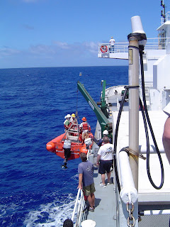
The new buoy has two of everything, and for the most part duplicate pairs agree. The only exception is wind direction, where the two devices disagree by 45 degrees or so. It is thought that a rope got caught slightly for a second on the little spinning instrument during deployment. At present, the planned solution for that is to send Sean out in a boat to climb aboard and replace it. This sounds rough for Sean but might make a good photo op for you and me. Stay tuned.
The extra measurements I mentioned involve lowering a rosette with a CTD (remember? it determines salinity and temperature at different depths) and some bottles for collecting water directly. Here's me in front of the suite of instruments.

Remember yesterday's question? Where do you store 7 miles of rope and cable? Most of it lives in these boxes and on these spools. I helped drag it out of the boxes, which was tedious and tiring, and I'm assured putting the old buoy line back in the boxes is no picnic. Breeze, an incoming UH student and a guy on my CDT team, is in one for scale.


Technician Kuhio has started fishing, but reports no bites yet. We've got a Massachusetts contingency here rooting for the Celtics and coveting a cable connection.
Aboard the R/V KILO MOANA
Date: 5 June 2008
Geographical Area: Central Pacific, North of O’ahu
The deployment of the buoy went fine yesterday, and now we're monitoring data from both buoys while we take some extra measurements of the water in the neighborhood of the buoy.
The new buoy has two of everything, and for the most part duplicate pairs agree. The only exception is wind direction, where the two devices disagree by 45 degrees or so. It is thought that a rope got caught slightly for a second on the little spinning instrument during deployment. At present, the planned solution for that is to send Sean out in a boat to climb aboard and replace it. This sounds rough for Sean but might make a good photo op for you and me. Stay tuned.
The extra measurements I mentioned involve lowering a rosette with a CTD (remember? it determines salinity and temperature at different depths) and some bottles for collecting water directly. Here's me in front of the suite of instruments.

The gray vertical cylinders on top are the bottles, and the black and silver cylinder strapped on lower is the CTD. The whole contraption is lowered by a crane, with me providing some sloppy assistance in steadying it, and it then yo-yos (scientific term) up and down through the top of the water column collecting CTD data, which we can see in real time on a computer inside. On its last trip up, the bottles are closed by a technician’s command, and my awkward self helps get the thing back on board. The operation is very controlled (despite my involvement and unlike my yo-yoing experiences) and takes perhaps 45 minutes.
I'm involved in a couple more data collection projects, too. One is taking humidity measurements on the bow with an old fashioned psychrometer (Did I spell that right, Proofreader Jim?), and the other is taking water samples from an indoor tap that they assure me draws directly from the ocean. Do you think they are making up chores to keep me busy?
Personal LogRemember yesterday's question? Where do you store 7 miles of rope and cable? Most of it lives in these boxes and on these spools. I helped drag it out of the boxes, which was tedious and tiring, and I'm assured putting the old buoy line back in the boxes is no picnic. Breeze, an incoming UH student and a guy on my CDT team, is in one for scale.


Technician Kuhio has started fishing, but reports no bites yet.
 We've got a Massachusetts contingency here rooting for the Celtics and coveting a cable connection.
Wednesday, June 4, 2008
Buoy Launching
NOAA Teacher at Sea: Patricia Kassis

In total, the ropes, chains and cables connecting the anchor to the buoy is about 7 miles long. How would you store that much thick rope? I'll show you the empties tomorrow...
Aboard the R/V KILO MOANA
Date: 4 June 2008
Geographical Area: Central Pacific, North of O’ahu
We just got underway yesterday, and today is very exciting. We’re deploying a new buoy a few miles from an old one, and we intend to leave both in for some days, and finally remove the old one before departing the area. The overall concept here is to get a really good dataset about the ocean and the atmosphere in one location over a long period of time. This program has been ongoing since 2004. These data will serve as a piece of the puzzle in the larger question of how global warming works, and what roles the tropical ocean and atmosphere play.

On top are the meteorological gadgets, which measure air temperature, humidity, solar radiation, wind speed and direction, and barometric pressure. A GPS unit there keeps track of the buoy’s location, elevation and orientation. There’s a fin to keep the buoy facing into the wind (preventing, for example, temperature sensors from being in contact with air that has already passed over other instruments or surfaces), and on the fin is a white capsule-looking object containing instruments to reflect radar from ships to avoid collisions, and a metal box which contains an antenna. With this antenna, all the meteorological instruments can send data to a satellite at regular intervals. You can see this data, graphed in nearly real time, at the website http://uop.whoi.edu/projects/WHOTS/whotsdata.html. On the buoy’s top you can also see bird wire, and I’m told I’ll understand fully the importance of this component when I see how guano-covered the old buoy will be.
A few instruments are located at sea level: carbon dioxide sensors (not shown) and sea surface temperature (SST) sensors. One SST sensor is embedded in foam and moves freely on a vertical rail, going up and down as the buoy bobs, trying to stay just at the surface of the water, and the second is fixed in place and is there for redundancy.

The carbon dioxide sensors are important, especially to us in
The third layer consists of instruments hanging below the buoy: CTDs (the bread and butter of physical oceanography) tell us about the temperature and salinity at different depths; and two types of current meters measure how the water moves, one uses little propellers, the other bounces sound off of plankton in the water. These are connected to the buoy and to one another by a segmented strand – including metal chain and cable at depths where sharks would bite through anything weaker, and nylon and synthetic lines to allow some elasticity at depths where sharks aren’t a concern. Nowhere in this length is a communication wire of any kind, and electromagnetic radiation won’t travel through water, so these gadgets can’t communicate with the above water world. Instead, they hoard their data. When we pull up the old buoy, we’ll be able to download a year’s worth of data from each instrument (after we clean off the gunk). We’ll also get to look for shark bites on the chains, cables and lines.

I have the bottom bunk in a stateroom that I share with another observer. She’s a college student interning with Woods Hole. Our room and the one next to it (housing two
In total, the ropes, chains and cables connecting the anchor to the buoy is about 7 miles long. How would you store that much thick rope? I'll show you the empties tomorrow...
Subscribe to:
Posts (Atom)